Resupply Stations – The Sectors
Summary
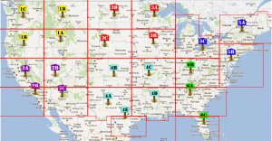
 A month ago, we introduced the Grid Concept for our resupply stations, where we broke down the continental United States into 23 Phase I sectors which will roll into 6 Phase II sectors. In order to keep outsiders (walkers or other kinds of predators) from discovering the whereabouts of the resupply stations — because let’s face, the last thing we want is a surprise visit while gathering the troops — we cannot refer to the resupply stations by city name.
 A month ago, we introduced the Grid Concept for our resupply stations, where we broke down the continental United States into 23 Phase I sectors which will roll into 6 Phase II sectors. In order to keep outsiders (walkers or other kinds of predators) from discovering the whereabouts of the resupply stations — because let’s face it, the last thing we want is a surprise visit while gathering the troops — we cannot refer to the resupply stations by city name. And while we have broken them into color-coded groups (North East – Blue, South East – Green, North Central – Red, South Central – Aqua, North West – Yellow, and South West – Purple), we needed a better way to identify the resupply stations without giving away any inkling of the location of the station. So each sector has been given a number and letter to signify its location. This makes it easy for reporting in to the resupply station. If the internet is still an option, check-ins via twitter would be something along the lines of @TheZSC Checking in sector #2D. Travel was quiet. Or if there were problems, they could be reported accordingly. @TheZSC Destination sector #2D. Shamblers enroute, diverting to avoid.
So how are the sectors laid out? Each of the 6 phase II sectors is assigned a number from top to bottom and left to right. Then within each of the groups, the phase II sector will be designated as the A of the group. The alpha sequence then follows a clockwise direction through the remaining locations. For easier visualization, please look at the full-sized version of the map. The breakdown is as follows:**Note** – The colors of the markers are not brigade specific — they are only indicative of the various resupply station groups.
North West Group (Yellow)
1A. Pocatello, ID (Phase II site)
1B. Lakeview, OR
1C. Yakima, WA
1D. Helena, MT
South West Group (Purple)
2A. Madera, CA (Phase II site)
2B. St. George, UT
2C. Phoenix, AZ
2D. Anaheim, CA
North Central Group (Red)
3A. Duluth, MN (Phase II site)
3B. Waterloo, IA
3C. Alliance, NE
3D. Bismarck, ND
South Central Group (Aqua)
4A. Midland, TX (Phase II site)
4B. Liberal, KS
4C. Springfield, MO
4D. Monroe, LA
4E. San Antonio, TX
North East Group (Blue)
5A. Burlington, VT (Phase II site)
5B. Wilmington, DE
5C. Cleveland, OH
South East Group (Green)
6A. Atlanta, GA (Phase II site)
6B. Berea, KY
6C. Kissimmee, FL
To read more on all resupply stations, please go to our (for members only) Key Links under the Escape Routes/Resupply Stations section

Anyone in the Blue Brigade 5C Sector with me?
If you want to check out which of your brigade members are in your sector, you can use the brigade map and click on the Blue marker at the bottom of the page and zoom in to the 5C sector area. Clicking on the marker in the legend of the map isolates the markers on the map to that one color.
I don’t see the Orange Brigade represented
The Orange Brigade is well represented. The colors used for the resupply stations are not brigade specific. The idea is that all the brigades gather at the closest resupply station to join forces, and supplies to enable us to move forward with strength.
Anyone in the Blue Brigade 5B? That’s where I am located, just haven’t been confirmed.
What about those of us not in the continental U.S? Am I the only one in Alaksa?
In the new year we will expand the resupply stations to a global scale. Alaska will be included in the plans for Canada. And there are a few other members in Alaska 🙂 But more recruits will help make the resupply stations a little more robust.
I like the concept.
Your choice to send survivors from Portland, the largest city in Oregon up to Yakima, WA… Not sure why. Seems to me that nudging the 1b-1c boundary up to the border, which is a huge river, could be wise. Depending on the disaster crossing the Columbia could be a very hazardous move.
Also, you will be sending every survivor from the ESOMA (Everett/Seattle/Olympia Metropolitan Axis), which has to be 70% or more of the Washington state population, over the Cascade mountain range to get to Yakima. So, Portland metro area survivors will be heading to the same place.
Likewise, Yakima is in the desert. Can the infrastructure handle a large influx of survivors?
Gladly follow orders to death even, but no mindless deaths.
We are not moving ALL survivors over the Cascades…the intent is to have a plan for the Zombie Survival Crew members proceed to the resupply stations. Being away from densely populated areas can be a plus as it will reduce the need for the crew to fight off those who will attempt to steal our survival supplies. And while we will certainly be open to people joining the ZSC during an apocalyptic event, we are not going to allow others to strip our stores.
Gotcha.
Still risky. The only way through to Yakama from here is either over the mountains or through the gorge. The gorge is full of the Columbia river, small towns, and shear cliff walls a couple hudred feet high. If zombies are an issue that route means fighting through those small towns in tight quarter. No way around them. I could be your man in Yakama (1C) but don’t expect me to be there in a hurry. That is serious road. And if people see me moving with a purpose they are going to want to follow…
For sector 1b you should reconsider Oakridge, OR… more centrally located to the population you expect to move, and there is an airport. There are a few small lakes nearby and it is well protected in the Cascades.
I’ll admit. I’m a little partial to the selection of 4A, having lived most of my life here. But be sure to stock up on water if you’re heading this direction – we’ve been under extreme drought conditions for well over a year now. Upside is you get two communities for the price of one, AND a local who knows her way around both. 🙂
How about adding this info to an Augmented Reality browser (i.e., Layar, Junaio, etc.) or location based app (i.e., Foursquare, Google Latitude). If internet and cell phone service is still online once something goes down, this could make for an easy way to find your way to your resupply center. Also, with most apps, comments can be made with time stamps (“main road to 5C is overrun, use extreme caution”) to keep others informed of the current situation, as well as see who is nearby (if those people are on their friend list).
At first, i like the Idea of sectors. But because im in Germany, what about Europes Resupply? Im in central Munich and im looking forward to recruit a few more members in this area.
If the Zombiepocalypse is starting we’re messed up?
I don’t think so.
Maybe some of the European Members of ZSC would like to make a plan by ourselfes, so we can be a vital Part for the ZSC?
Lets prepare ourselfs in the Hole world against the Zombiepocalypse
We haven’t forgotten about our European crew members!! Things have been severely hectic around command of late, so we haven’t been able to work on the sectors beyond the United States as yet. But you have a great idea. Why don’t you work on what the European sectors should look like and send the plan into command [at] zombiesurvivalcrew (dot) com. Thanks for suggesting it.
All of our crew members are vital to the Zombie Survival Crew. ::crossbow salute::
Great. I get my Zombie Squad together and we think it over. Thx
Excellent. We look forward to your plan.
On the border between 6A and 6C-definatly a waypoint when transitioning between phase 1 and 2…