We put out the call for local information on resupply stations and rendezvous points, and the Zombie Survival Crew continues to respond. Information is coming in and we’re sifting through and compiling everything for communication to the loyalists. We started with information on South Central Resupply site Midland, TX thanks to Purple Brigade member, Kris O’Dell, continued with Wilmington, DE compliments of ZSC Yellow Brigade member Brian McCabe, and Blue Brigade member Jenni Womick brought us Trinity, and we now move forward with Sergeant at Arms, Sarah Quattrocci. Deep in the mountains of Vermont, she has located the perfect meeting place for the Blue Zone.
_______________________________________
Assuming that higher-population areas are high-risk, finding a location off the grid but not completely inaccessible is key. Just outside of Burlington, VT and easily accessible from both Northern and Southern areas West of the mountains via Route 116, this location is a safe distance from the more heavily populated areas. Located on Route 116 just north of Hinesburg village on the east side of the road.
Access from New York state can be made by crossing the Crown Point Bridge and following Route 17 to connect with Route 116 at the Junction in New Haven, VT.
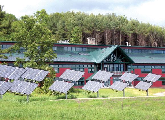
This building is not only spacious and designed for the long haul, but also combines security with at least some of the comforts of home. The building is powered primarily by a photovoltaic system (solar power), a 10-kilowatt wind turbine and uses another renewable resource such as wood pellets made from lumber milling waste for heating.
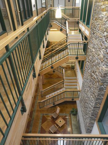
The core of the building features a large, open-concept common area constructed of concrete, wood, natural stone and other natural materials. It includes a 3-story stone fireplace to help keep the entire area heated during the colder months. There are dozens of skylights and operable windows to take advantage of natural light, provide natural ventilation and fresh air and allow full views of the outside.
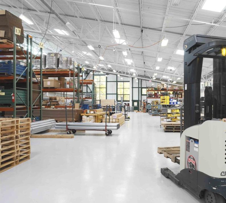
Situated within walking distance is a grocery store, hardware store, gas station, doctor’s office, police station and – perhaps most importantly – a large secure warehouse that is ideal for storage of supplies.
To read more on all resupply stations, please go to our (for members only) Key Links under the Escape Routes/Resupply Stations section!
Kissimmee, FL—Most people would say Disney right off the bat! But, is this where you want to be during the zombie invasion? I don’t think so! I don’t even want to think of the Magic Kingdom under those circumstances!
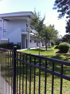
I chose Trinity School for Blue Brigade-Phase 1 Resupply station. The school is located on West Vine Street in Kissimmee, FL. West Vine is also known as US Highway 192, and Irlo Bronson Highway depending where on the road you are located. This is the main road in Kissimmee. It actually runs through a good portion of the middle of the state to the Atlantic Ocean. So, the school is easily accessible.
The school, is actually on a little campus that consists of several buildings, all of which are already fenced in. The school building is an older, two-story building that resembles an old motel. There are stairwells at both ends of the building, and an elevator (if power was on) in the middle. There are public restrooms in the middle on both stories. There are limited windows, and they are high up. Each classroom has an outside door, and a door inside that links it with the room next to it. There are also restrooms between the classrooms, and sinks in each room.
The other main building is the Family Life Center. This is a gym, with a large kitchen, restrooms with showers, and two other rooms that could serve many uses. There are very few windows, and the majority are very high up.
The other buildings on the campus are a church. There are restrooms, and other rooms and some offices here. Again, few windows. There is a another long building across from the school that has offices, a lounge and storage. There is also a fellowship hall that has a second large kitchen and an area for meeting. There are 2 small storage sheds, and in the very back of the campus there is an old house that now serves as day care-with a 3rd kitchen in it.
Since the entire campus is already fenced in, it would be not to difficult to fortify it and make it stronger. The aerial picture shows the entire area, but it’s old so there are no fences. The fences were added about 3 years ago.
For supplies, the school is in a perfect location. Directly across the street is a WalMart, and some other random stores (including a comic book store-study material for zombie killing). Next to that plaza (kiddie corner across the street to the right) is a Target and a Home Depot. Next to the school on the right there is a Play It Again Sports, and next to it on the left is a gas station. And, for the adventurous ones, a K-Mart and Big Lots about 2 blocks away.
Also, less than 1 mile away is the Kissimmee Gateway Airport. This is a “small” plane airport (no commercial planes). If any of the planes were flyable, this could be a HUGE asset.
_____________________________________
To read more on all resupply stations, please go to our (for members only) Key Links under the Escape Routes/Resupply Stations section.
We put out the call for local information on resupply stations, and the Zombie Survival Crew continues to respond. Information is coming in and we’re sifting through and compiling everything for communication to the loyalists. We started with information on South Central Resupply site Midland, TX thanks to Purple Brigade member, Kris O’Dell, and continue now with Lewes, DE compliments of ZSC Yellow brigader Brian McCabe. Because of the amount of information Brian provided, we’ll post this in multiple parts.
Rendezvous Point Cape Henlopen
2 hours via Vehicle from Point Blue Rocks – Easy Access Rt. 1 to Rt. 9 to Cape Henlopen Dr.
Cape Henlopen State Park is an old World War II base that not only has observation towers, but bunk houses and a bunker system as well, for optimum security. It also has several large buildings that can be used for housing and/or a Command Center. There is a fishing center for a natural food supply, and the University of Delaware and the US government have a high-tech weather center that could provide a key to communicating with others at some point.
The facility will have a variety of valuable supplies in regards to primitive living, tools, hunting and fishing equipment, resource management tools, etc. One key point for this location is it sits next to the Cape May Ferry, which will not only have supplies, but it also houses various size boats. Quite useful in either falling back to the Phase 2 site or reconnecting with Phase 1’s site in Southern New Jersey. This site also sits just outside of Lewes, which has a variety of retail, restaurants, and a large hospital. Lewes also has a boat yard, which docks everything from sail boats to charter fishing boats.
To read more on all resupply stations, please go to our (for members only) Key Links under the Escape Routes/Resupply Stations section.
Biggest shopping center in the area is Crossroads Mall at 2060 Crossroads Blvd. (It does have a Scheels in there) [***Note*** For the uninitiated, Scheels is a sporting goods store which carries items which will be necessary during a zombiepocalypse] There are also several hardware stores in the area, such as the Menards on 1051 East San Marnan Drive, which is the one I’d go with when it comes to accessibility, it’s at 1051 East San Marnan Drive, there’s a Home Depot very close by though, at 1050 Southtown Drive. And at 1051 East San Marnan Drive is a Target, close to that at 1334 Flammang Drive is a Walmart Supercenter. Literally just up the road from Target is a CVS Pharmacy at 1825 East San Marnan Drive.
I would stay with these locations for resupply, simply because they’re so close to each other in proximity, and close to I-380 which is a main thoroughfare, but also crosses just north of Highway 20, which runs east-west. There’s a Dick’s Sporting Goods close to the Wal-Mart at 1411 Flammang Drive.
As for routes there, some might say I-80 but that’s WAY south of Waterloo. For those coming from the south, I-380 is a good route but it’s pretty open, it’s the main north to south route in Eastern Iowa. Highway 63 is a good north-south alternate, it runs straight through Waterloo. Conversely, those coming from the north or south could take I-35 to 20 and go east. East to West I would go with Highway 20. It’s well traveled, but not as large as 380 is.
But just so you know, there’s a National Guard Armory in Waterloo as well, 3106 Airport Blvd, in Waterloo. It’s about 8 miles north though, of the various stores and such I listed above.
Thanks again for the information, Chandra, you have done your brigade proud. Waterloo has a lot to offer for Zombie Survival Crew loyalists. Plenty of places to stock up supplies, and it certainly doesn’t hurt to have a National Guard facility in the backyard.
To read more on all resupply stations, please go to our (for members only) Key Links under the Escape Routes/Resupply Stations section
GET A MAP! Seriously. This is oil country and you will get lost without that nifty folded up piece of paper. GPS is practically useless out here, too. You do not want to try to avoid the shambling hoards without one, so don’t blame me if you turn down an unmarked road thinking it will intersect with a highway and it only dead-ends into an oil rig with 20 zombified roughnecks. With that warning firmly in place, here’s a list of what highways to find and how to get to UTPB from them.
Interstate 20 (coming from the west): The interstate highway skirts the south end of town and is probably the safest route through Odessa. You can exit on John Ben Shepperd Parkway and head north for appx. 2 miles until you intersect with University Blvd. UTPB is the Northeast corner. A)If you continue north on JBS, turn into the university at the first light. Merge to the right onto UTPB Circle, then enter the parking lot to the left. The building on the right is the library, the one on the left is the Mesa. B)If you turn east (right turn) onto University, keep to the left lane and turn into the university at the first light. You will pass the dormitories and come to a stop sign. 1)left turn takes you to the same parking lot as in option “A”, which will be on your right. 2) right turn takes you past the S&T building to the gym parking lot, in which you can access the second floor of the Mesa from the ramp between the gym and the S.A.C. building.
Highway 302 (coming from the west, intersects with hwy 285 north of Pecos, TX): 302 will intersect with Loop 338. Head north on 338. (Unless you’re brave and want to drive through town, but I wouldn’t suggest it.) Take it all the way around to the other side of Odessa. When you get to the 191/42nd Street overpass, turn right (west). Now, this is where you pray that it really IS the apocalypse and that there’s no traffic, because once it intersects with the highway, you have about ten car-lengths to cross 3 lanes of traffic to the left in order to turn into the University from Preston Smith Road. Once on campus, you can either A) go straight, and the SECOND parking lot is the gym parking, where you can get to the Mesa building from the ramp or B) turn right until you get to the HUGE parking lot in front of the Mesa.
Highway 385 (coming from the north): Intersects with Loop 338. Pretty much the same instructions as Highway 302. An alternate for both of these would be to exit 338 at JBS parkway (turn right, head south) instead of at 191. Just south of 42nd & JBS is lesser used entrance to UTPB on the left, across the street from Wells Fargo. If you blink, you’ll miss it. This will take you directly to the Mesa building.
Highway 349 (coming from the north): Welcome to Midland. Take Loop 250 west until it intersects with Highway 191. Then take 191 west to Odessa. It’s about 15 miles. The first light is Preston Smith Road – turn left into the University. You can either A) go straight, and the SECOND parking lot is the gym parking, where you can get to the Mesa building from the ramp or B) turn right until you get to the HUGE parking lot in front of the Mesa. (Yes, that was a copy/paste job, smarty-pants.) You can also take Loop 191 to Highway 80/Business 20 or Interstate 20. Those instructions are next.
Interstate 20 or Business 20/Hwy 80 (coming from the east): OPTION 1 – Exit Loop 338 and head north. Turn left onto University Blvd and then turn right into the university at the first light. You will pass the dormitories and come to a stop sign. 1)left turn takes you to the Mesa/library parking lot, which will be on your right. 2) right turn takes you past the S&T building to the gym parking lot, in which you can access the second floor of the Mesa from the ramp between the gym and the S.A.C. building. OPTION 2 – exit at John Ben Shepperd and follow instructions for west I-20 as listed above.
Highways 158 or 349 (coming from the south into Midland): You’re going to intersect with I-20. Read the paragraph before this one on coming in from the east.
Highway 385 (coming from the South into Odessa): Surprise. You’re going to intersect with I-20 on the west side of Odessa. You need to go back to that first set of directions up there.
Notice! Do not expect to be able to get to UTPB from Loop 338 unless you’re using it strictly as access to University Blvd or 191/42nd Street. There are two turn-ins: a park and a (golf) driving range. Neither of these facilities has a direct road to the main campus.
We put out the call for local information on resupply stations, and the Zombie Survival Crew has responded. Information has been trickling in and we’re sifting through and compiling everything for communication to the loyalists. We’ll start by sharing some information provided by Purple Brigade member, Kris O’Dell. Because of the amount of information Kris provided, we’ll post this in two parts. The general information today and the directions a week from now.
Midland, Texas. It’s a nice place to live. Go to school. Raise a family. Work that shiny white-collar job. And a good cover for where you REALLY want to go in case of the zombie apocalypse. For that, you want to head to Odessa, Midland’s blue-collar twin fifteen miles to the west. Home of the University of Texas of the Permian Basin, and your ultimate destination.
UTPB has exactly what you need to bunker down during the apocalypse. The Mesa Building is the most defensible structure on campus and ideal for both long and short term occupation. It stands four stories tall with multiple ground floor exits, a second-story patio that wraps around the entire structure, and balconies on the third and fourth floors. There are six sets of enclosed stairwells connecting each level of the Mesa Building.
Along with multiple classrooms, the Mesa is home to the administrative offices, the student union and campus security/police headquarters. There are computer labs on the second and fourth floors. Each level also has vending machines and multiple restrooms. The patio connects to the second floor of the gymnasium, where survivors can utilize the medical clinic and shower facilities. The gym also has a weight room and a fenced outdoor swimming pool.
Other buildings immediately near the Mesa include the library, the science and technology building and the student activity center. Each building stands at two levels. Beyond the obvious cache of knowledge, the library has more vending machines and computers. The S&T building is home to another computer lab, biology/chemistry/geology labs and could possibly contain medical equipment used for training the pre-med and nursing students. The S.A.C. has a coffee shop, game room, weight room, cafeteria and the campus child care center.
Other buildings on campus include two museums, an art studio and outdoor athletic facilities. UTPB does have apartment-style student housing, but they would not be as secure as the Mesa. However, raiding them for beds and other supplies would be perfectly acceptable. The true outlying goldmine is the fire station on the south end of the campus property.
UT Permian Basin wasn’t chosen simply for the campus itself. There are several places in which to get various necessities within one mile, making supply runs a much easier task than they would be in other areas in the community. In fact, most of them are right across the street. To the north: Wal-Mart Supercenter, Sam’s Wholesale Club, Family Dollar, Home Depot, Best Buy and Academy Sports. South: University Pharmacy & Medical Supply, Westlake Hardware, Hobby Lobby and Dollar General. West: Animal Clinic and Albertson’s grocery. There are five gas stations, three hotels, a handful of shopping centers and over a dozen restaurants within the same area. Oh, and the mall is kitty-corner from the campus to the northwest.
Thanks again to ZSC Purple Brigade member, Kris O’Dell, for this valuable information.
To read more on all resupply stations, please go to our (for members only) Key Links under the Escape Routes/Resupply Stations section

 The school, is actually on a little campus that consists of several buildings, all of which are already fenced in. The school building is an older, two-story building that resembles an old motel. There are stairwells at both ends of the building, and an elevator (if power was on) in the middle. There are public restrooms in the middle on both stories. There are limited windows, and they are high up. Each classroom has an outside door, and a door inside that links it with the room next to it. There are also restrooms between the classrooms, and sinks in each room.
 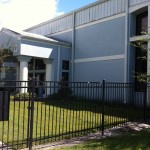 The other main building is the Family Life Center. This is a gym, with a large kitchen, restrooms with showers, and two other rooms that could serve many uses. There are very few windows, and the majority are very high up.
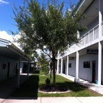 The other buildings on the campus are a church. There are restrooms, and other rooms and some offices here. Again, few windows. There is a another long building across from the school that has offices, a lounge and storage. There is also a fellowship hall that has a second large kitchen and an area for meeting. There are 2 small storage sheds, and in the very back of the campus there is an old house that now serves as day care-with a 3rd kitchen in it.
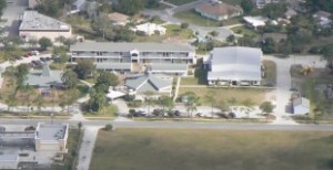 Since the entire campus is already fenced in, it would be not to difficult to fortify it and make it stronger. The aerial picture shows the entire area, but it’s old so there are no fences. The fences were added about 3 years ago.

 The facility will have a variety of valuable supplies in regards to primitive living, tools, hunting and fishing equipment, resource management tools, etc. One key point for this location is it sits next to the Cape May Ferry, which will not only have supplies, but it also houses various size boats. Quite useful in either falling back to the Phase 2 site or reconnecting with Phase 1’s site in Southern New Jersey. This site also sits just outside of Lewes, which has a variety of retail, restaurants, and a large hospital. Lewes also has a boat yard, which docks everything from sail boats to charter fishing boats.


